Trail Run & Training Progress

Much like the unstructured trail run I went on last weekend, I’m just going to start writing this blog post and see where I wind up.


Right now I’m just focusing on endurance, attitude, and form. The individual runs are relatively unstructured, allowing me to hone in on those aspects. Rather than holding a specific pace for intervals, I’m just going for an overall zone each run. Next month I will start to add in interval workouts, necessitating putting down more detail in advance, but right now I’m enjoying the process of just going for a run without performance expectations.


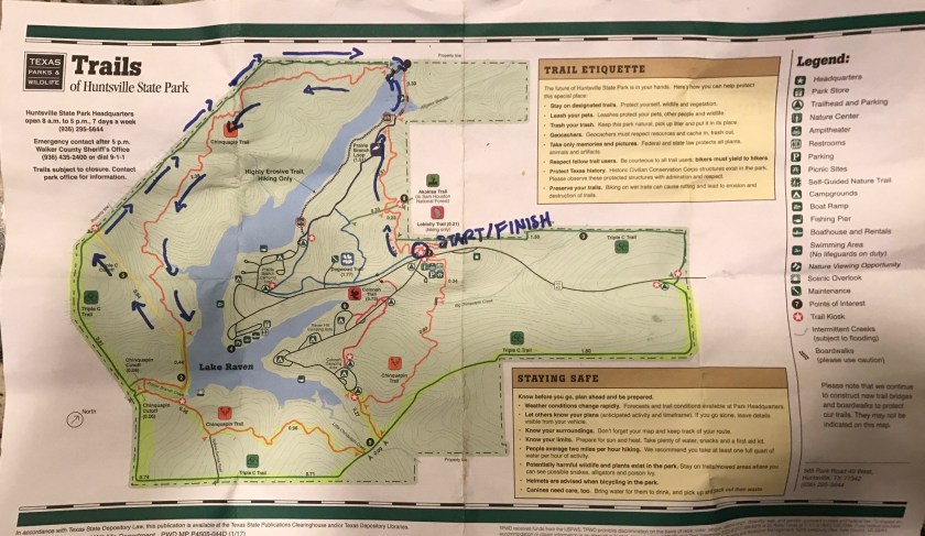
Last Sunday I had a trail run scheduled, but I didn’t know where I was going until that morning. I had some backup ideas in case I wasn’t divinely inspired, but I didn’t need them. I glanced at the list of trails listed in the front of the book, and picked a park to head to, not even sure which route I would take once I got there. I had selected Huntsville State Park, north of Houston. My first trail run when I moved back to Houston was near the park, and I hadn’t been back to the area since. In my head it was maybe an hour north, but I wound up driving quite a ways, over an hour and a half, listening to Hidden Brain podcasts during the drive.


I arrived at the park, was given a trail map with closed portions highlighted, and parked at the first spot I saw next to a trail head. I kinda had an idea, looking at the map, that I would run out on the Chinquapia Trail, a 6.8 mile loop around the lake, but might turn back after 3 miles because part of the loop was closed. I forgot all this. The beginning of my run was kind of confusing. If you look at the map, you’ll see that the arrow pointing north is on the diagonal. As I ran and crossed certain paths and landmarks, things weren’t jiving in my head, so I just meandered, somehow still staying on Chinquapia without really trying to.


This was my favorite trail run so far in Texas, and I will be back. The ground is great, with technical stuff to maneuver, like roots and rocks. The path winds, it’s never fully single track but really fun to navigate all the same. I got so lost in my enjoyment of running this trail that I forgot to turn back at my 3 mile mark, and when I got to the closed off portion of the trail, realized I could still make a loop (see map below), but I’d be adding 2 miles to my run. Oh, well- if I was feeling tired or sore I could walk. A big portion of this training phase is not overdoing it- I want to get to interval training energized and ready to work hard. I had only planned on running 16 miles total for the week, and 5.5 for the day, but wound up running that last two making my total mileage for the week 17.7 with the day’s run being a total of 7.2. I called the run before reaching my car, deciding I’d tacked on enough extra mileage, and walked about another ¾ of a mile to finally get back to my car.


I had my first fall since breaking my ankle in 2015! I’m excited because I came up without a scratch and more importantly without any muscle or tendon injury. This was super exciting. The fall itself was surreal, I tripped over a root, and time froze as I wondered whether I was going to be able to find my footing or go down. I went down, and didn’t fight it. This is the way I typically fell in the past, not trying some awkward footing last minute to save myself a little scratching or bruising. I did try to stop the fall when I had the ankle break, and I hope that lesson to just let the fall happen sticks forever.


Finally, last month I decided to pull back on the intensity of my training, while still progressing with distance, and this month I’m seeing positive results. My average pace is dropping, I’m recovering faster, and focusing on form has led to me running faster even though it feels like I’m putting in less effort.


Lesson:

  • Evaluate where you are and where you want to be. Create a plan that makes sense to take you there. Harder doesn’t always mean better, but smarter usually does!


One of the benefits of having a plan is that I never wonder if I should go for a run. Its right there in front of me, the next step I need to take to be the kind of runner I want to be.

IMG_1157
The route I ran is marked in Blue. There was a little more steady incline on the back end (Green Route/Triple C Trail), otherwise little hills throughout. A really FUN RUN!

Here Comes the Airplane Mode!


To bring or not to bring the phone on your run? One day, I wound up putting it on airplane mode a mile in because the damn thing would not stop buzzing. Texts & app notifications were zooming in one after the other, and after the 5th notification I started getting irritated, so I cut the line. Since that day, I have been putting it on airplane mode before I even start my run, or leaving it home completely when I’m just in my neighborhood.

My current goal is a sub 22 5k, and I’ve structured my fitness training to a few runs a week, so I need to focus on what I’m doing in them. On my current runs, I don’t want my attention to wander too far from my feet. I was recently videotaped running, and my form needs work. That requires concentration. I have a habit of letting my mind wander when workouts get tough, and as a side effect, I slow down. Again, my full attention is needed for the task at hand, which is bringing myself to the pace and form that I want to eventually stick. That’s what training is- it’s practicing until you don’t have to practice anymore. When you get to your goal, you can relax or set a new one. That being said, sometimes I’ll allow, maybe even encourage, my mind to wander while I run, to take a detour wherever it wants. This is usually a part of my trail runs, and honestly not a big part, because when I don’t pay attention, I fall. It happened just today, and I’ll write about it in another piece about my run in Huntsville State Park, TX.

Leaving my phone off or at home allows me the space to meditate, without distractions taking me places I don’t really need to go at the moment. I found I like leaving my phone off so much on my runs, that I’ve started deliberately turning it to airplane mode at home as well. So far there have been no emergencies that called for me to save the day, and I haven’t missed any opportunities from diverting digital signals away from me. I hit the plane, and think, “I’m good, you guys can go on without me, and I’ll catch up to you later”.

IMG_1080
Wouldn’t you want to give this your full attention, too?


Of course, I like to have my phone with me to take pictures for this blog and my Instagram account, but it has become a level of obnoxious to bring with me. I have tried various methods:

  • Belkin arm-band (from Target)
    • Pro: it’s a well-made brand that I’ve never had to replace for wear and tear, only phone models, for years
    • Con: the size of my iPhone 7 against the relative thinness of the arm band feels uncomfortable- think “floppy”
  • Nathan water bottle (REI)
    • Pro: I love this product as a water vestibule, but…
    • Con: the phone barely fits, really have to wrestle it in.
  • expandable-mesh waist pouches
    • Con: they don’t rank high for comfort for me, and they can move around a lot.


So my question for anyone reading this is- Being that I still like to have my phone on me for emergencies, does anyone know of arm-band that fits iPhone 7 and sits securely on runs? Or is there some other type of phone carrying device I haven’t thought of or mentioned above? Thanks and

Trail Runs in Houston, TX: Cullinan Park and Brazos Bend State Park

This past week I explored two new places to trail run in the Houston area. The first, Cullinan Park in Sugarland, was recommended to me by a friend, which is great because I was unaware the park existed, and the second, Brazos Bend State Park is very well known, at least in the area.


CULLINAN PARK

My sister and I headed out to Cullinan on Sunday. I had looked at park online and from my friend’s report gathered I would probably be running around 3 miles. Arriving there, I realized there was a main trail consisting of a 1.5 mile loop, but there were off-shoot trails and connectors, so the total amount of mileage was a little over 3 miles. One of the trails, the red trail, appears to end on the map, but it actually continues through the woods and around the lake, and I recommend going the whole way, which will bring your right around to the parking lot.


This is a great park for people looking to get some easy, fun, trail running in. It’s in Houston, so its flat. But it offers a variety of scenery; especially considering the small area the park takes up. It’s not far out of the way of anything, being just a few miles from I-69, and parking was free. The only bathroom available was a porto-potty, so if that turns you off, just go before you arrive and you should be fine for such a short run. We went on a Sunday with pretty pleasant weather, and the park was not crowded. Most of the visitors stayed near the parking lot, as there are viewing decks to see wildlife- we saw baby alligators!


As you can see from the map below, these trails have names, but I appreciate the simplicity of their color-coding on the map and will use that for reference. When you get out there, you will find colored bands on trees for the individual trailheads.


IMG_0863.jpg

From the parking lot, we went to the main trailhead, and took the green route to the first off-shoot of the blue route, and from there took the red route. On the red route we came across a pretty interesting scene, but I wont give away what that was here! As I said, the map shows the red route ending, but we were able to make it around the lake and back to the parking lot, still on trail, where we started at the main (green) trailhead again, this time taking an immediate left to go in the other direction on the green trail. We followed that around to the lavender trail. This was the least interesting trail in the park, to me. If you want to get the mileage, great, but if you’re looking to cut something, it’s just wide and flat, and dead-ends at a canal with a view of the road. We went back towards the green trail on the lavender trail, I took a little side jaunt to check out the turquoise trail, which had a pretty enchanting vibe, before we headed back to the parking lot on the green trail.


It was a fun run. Aside from the lavender trail, you’re looking at mostly single track or close to it. There’s plenty of shade, and for its size and location, I didn’t feel like I was running anywhere near a city (save a few glimpses of neighborhoods on the red route). There were some tricky areas to navigate, If you want to get to the other side of the green trail from the trailhead, take the second or third crossover, the first took us off the path as we had to navigate around some muck and water, but you’ll see that from the main path. The only path we didn’t take was the yellow, and as I ran ahead and doubled back to join up with my sister a few times, I was able to turn 3.3 miles of trail into 4 easily, and it’s worth repeating that the scenery changes often, and it’s all very pretty.


BRAZOS BEND

The second trail run of the week took me out to Brazos Bend State Park, southwest of Houston. It’s a very well-known park in the area, the upkeep and amenities are fantastic, and the staff is friendly and helpful. When I arrived, I purchased an annual Texas State Parks pass ($70), and the ranger assisting me was able to recommend trails to run on, as well as which ones to avoid because they were still recovering from heavy rain.

The website claims 37 miles of hiking trails in the park, which I believe includes the paved areas as well, and I covered around 6 or so. I’ll share what I did that day and update the blog once I explore and find out more. I’m including an image of the map the ranger gave me, with his recommendations highlighted in yellow, and what I actually ran in blue marker. (I ran out a bit on some other trails to get a look around, which is how I covered 6 miles). The black “X” marks trails I was to avoid.

IMG_0862.jpg


I parked behind Elm Lake, right at the turn-around, and took the Elm Lake Loop Trail to the Spillway Trail. If you didn’t know, Brazos Bend is known for its wild alligator population, and I was not disappointed. Not one mile into my run, I saw two from a bridge on the Spillway Trail, then came across one right on the path. I wasn’t sure what to do, as cautionary signage insisted on giving the animals a birth of 30 feet, which was impossible with water on both sides of the trail. I don’t know how fast alligators are, but I remembered a friend saying he just ran by them in the park all the time. I started to approach, and at that moment the formerly still reptile started moving its legs and opening its mouth at me, and I was done. I had planned to take the Spillway Trail around 40 Acre Lake, but I turned back and made my way back to the Elm Lake Trail.


When I came to the Pliant Slough trail, I took that. The ranger hadn’t mentioned it as good or something to avoid, and I’m glad I ran it. The ground was super springy, and I was reminded how much better it feels to be off of concrete. The trail was only a mile long, and I was loving the stretch so much that I was tempted to run it twice, but instead took the trail back around to the observatory, where I made my way back around Elm Lake once again. When I got near my car, I ran past to the Horseshoe Lake Loop, trying to get to at least 6 miles.


I didn’t even cover a third of the mileage in the park, but of what I did see, none of it was single track, and it was all very flat. Still, it’s a great place to get in long runs off of the concrete, if the pretty scenery doesn’t interest you, watching for alligators will keep you from getting bored!