Trail Run in Australia: Blue Mountains, NSW Pt. 2

Some current events before I get started: As I write, New South Wales in Australia is experiencing some of the highest temperatures on record, and the conditions have lead to Australia’s largest population of bats, a particularly large breed known as flying foxes, to die in record numbers. As colorfully as the news describes the situation- “brains boiling” is a phrasing that comes to mind, this is distressing on many levels. Maybe you are an animal lover, and this news is distressing in itself. If you are reading a blog that features trail running (thank you, btw) I imagine you have at least a basic appreciation for natural beauty and processes. One of the implications for such a large death toll in this animal population is that the forest canopy will not have the support it needs to maintain coverage and increase growth. These bats are responsible for building their own environment- they are fruit bats. They eat fruit, disperse the seeds, and the forest grows. Less bats –> less seed dispersal –> less forest growth –> less coverage from extreme heat –> less bats. The problem will be exacerbated as temperatures rise, which climate trends suggest will happen. Read more about the wildlife of Australia and the current events effecting them from people who know what they are talking about here!


The last place I visited during my stay in the Blue Mountains was a place called Sassafras Gully. It was freakin’ magical and you need to go there. I was told of the place by some hikers I met on the Mount Banks Trail. I immediately wanted to go check it out, if only to verify its existence because “Sassafras Gully” was almost too perfect a name…these hikers could have made it up.

I planned on finding my way to the trails again the day after Christmas. Weather was not great on Christmas Day, and my Airbnb host had kindly invited me to a party down the road at her friend’s restaurant. I went, stuffed my face, hung out with her and her lovely family, and generally had a blast chilling out for a day. Weather did not much improve the day after Christmas until later in the day, but that was fine. I found a Starbucks like a good American and holed up with some caffeine and wifi to get work done. I also used the poorer weather as an excuse to take time and visit Featherdale Wildlife Park. because I hadn’t seen any of those cool Australian natives up close yet. This is where I actually saw one of the flying foxes I wrote about above. My favorite animal to observe up close there was the Tasmanian devil, because Looney Toons. What can I say? My recipe for a good life starts with a healthy mix of simple reference points flavored with new experiences, spiced up with from-left-field mindset changes. Also, I hate cooking. Don’t know why I went with a kitchen reference. Where was I?

Sassafrass Gully Run
The longer, straighter trail is the one I ran, Yondell Extension, which goes out to some pretty cool views and is a nice little warm up exercise to mellow you out for some slower hiking.

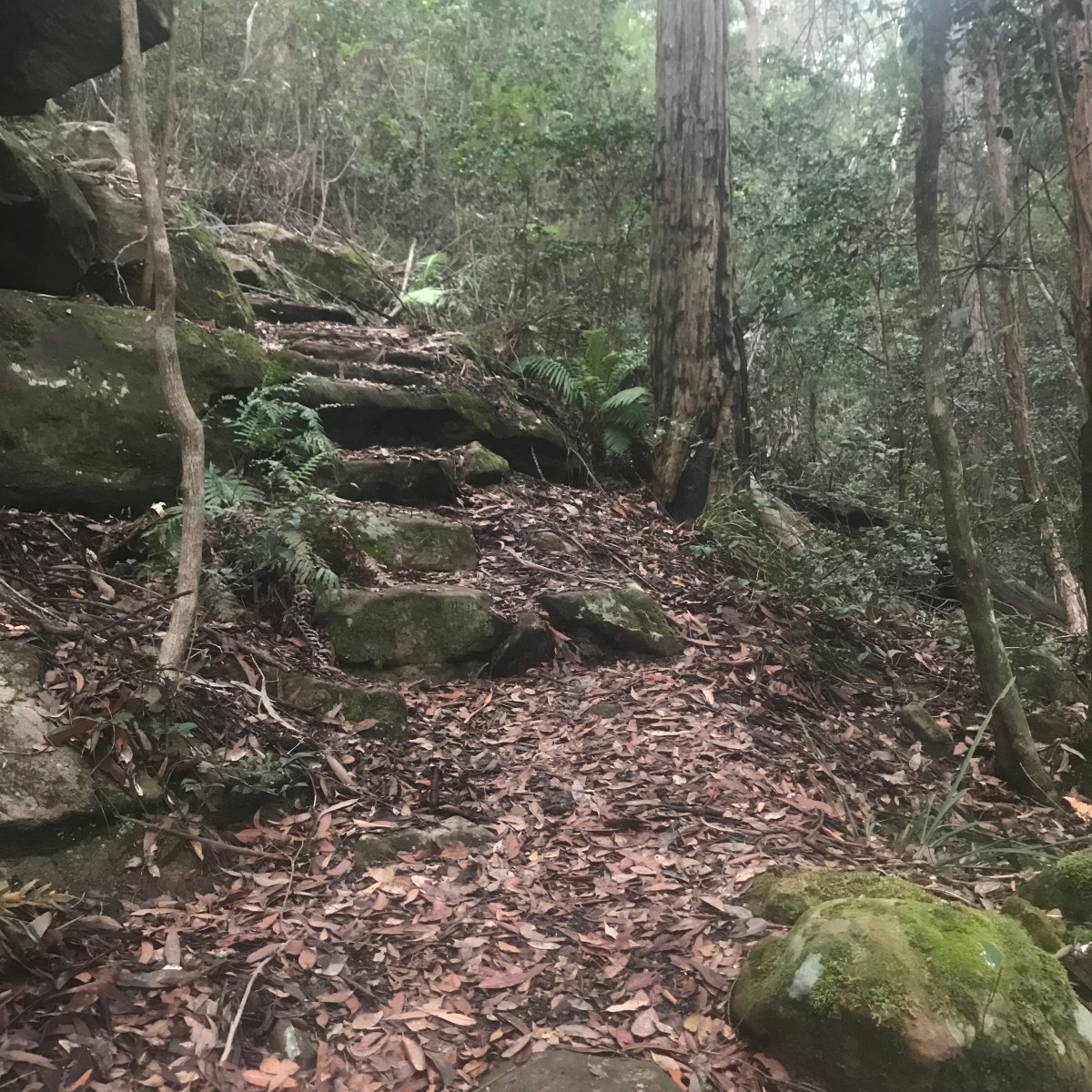
Ah yes, Sassafras Gully! Ok- so if you have seen Fern Gully, keep reading. If you haven’t, set this aside, go watch the movie so you can catch up on childhood in the 90’s and know what I am talking about. As I made my way through the place, I was fully ready to run into fairies. Or a hobbit. It was lush, there was moss covered stone everywhere, and it was really quiet for being located super close to a neighborhood. The stones made steps that lead down the escarpment to more lushness and more moss covered stone. It was a different time of day and season of the year from where I started and where I descended to. I wasn’t able to run much but had an enchanting time hiking instead. I actually was able to get a run in on the top of the ridge before I got started on the “Yondell Rd Extension”, where I parked.

The trail I took down to the gully was the Wiggins Track. If you look at the map for where I parked above, you’ll see there’s a considerable network of trails, including one called the “Batman Trail”. I did not see or know of this before I left and of course now I have to go back for just that.

Here are some pictures that do no justice:


Trail Run in Australia: Blue Mountains, NSW Pt. 1

I saw a pretty place with interesting looking trails on an Instagram account I follow & decided to go there over Christmas.

You did what for Christmas?

I saw a pretty place with interesting looking trails on an Instagram account I follow and decided to go there over Christmas. I had been looking for a good destination for a solo Christmas running trip, and I may make traveling for that holiday my thing, we’ll see. I’m not a Christmas hater, but I’m a traveling lover and it was just the right timing for me to take off. I had a great time and felt really peaceful for the holiday, so I could see it sticking.

I found a place in Bilpin on Airbnb, and messaged the host to make sure that my stay wouldn’t interfere with her holiday plans. I did some research on trails in the Blue Mountains, setting one aside as a first day must do, and then highlighting some other options. Rather than over-plan, I figured I could always ask around once I got there, since at least I spoke the language this time. Before I left I was worried I wouldn’t have enough to do in the mountains over the holiday, but as it turned out, I wore myself out the right amount with adventurous days to enjoy early low key nights.

Mount Banks

It was over 90 degrees, but I flew a long way to run here, so I just made up my mind that it wasn’t going to be a factor. I filled my pack, and made sure that when I was running low on water that I was already on my way back to my car. I had bought a large dispenser from the the grocery store, which stayed in my car the whole time so I never had to worry about finding water at or before getting to a site. It was such a great run that I didn’t even notice the heat.

The lookout at the turnaround point is just incredible, with many different points to just sit and take in the view. My pictures don’t really do it justice but here they are anyways! the total distance I ran was 4.6 miles, with going off and turning back included. If you just went out and back I imagine it would be around 8.5 miles. I found in Australia, walking tracks are given “finishing times” more than distances, so I’d do a little covering before starting out each time- yay math!

28912128_Unknown
I took the “Via Ridge” route, and while there were some steeper sections, they were not long, and I found the grade overall completely run-able.

I did a turnoff to the Mount Banks lookout from the main trail indicated above, but that path was really overgrown and I found myself doing more hiking than running, and I returned to the main trail. On the way back I went right to a side trail instead of left   which would have led me back the way I came. That trail also became very over grown but was fun to run for a bit if you want to check it out, and maybe in another season it will be easier to get through!

I started a new workout on my watch for the way out and the way back, which is how I have two separate maps. The maps below show the main route, as well as the turn off I did on the way out up to Mount Banks (left), and then the little side route I did before I ran back to my car (right).

Map & Parking: Turn off of Bells Line of Road to the dirt road, and drive until the end.

Katoomba

The trails I was after were headed at a spot full of tourists, arriving by bus, and by car. There is a great lookout spot, and while many were hiking, most were just driving in for a view and then leaving. There was parking available for a fee, for up to 8 hours. I was lucky enough to arrive early that I found a space right away, but when I left people were waiting on the road for spaces to open up, so I’d recommend getting there early if you are driving. Even though there were a lot of people around, I found myself alone on the trails away from the lookout points quite a bit.

I took the Prince Henry Cliff Walk to Federal Pass, then came back up to where The Three Sisters, a geological formation that was super popular for photo ops, were on my way in. Going down and coming back up meant using stairs. Both routes were steep but had rails where you needed them. I grabbed a shot in front of the valley beyond the rocks. There was no one on that lookout spot except for the person holding my camera, so I was able to take in a final view without having to hustle and duck.

fullsizeoutput_e22

I really enjoyed this run. Parts of it had to be walked- like the stairs, but the rest was great for trail running. Also, the landscape was varied for such a short run (4.1 miles). There were stunning views at the beginning and end, and cool waterfalls, vegetation, and serene surroundings in the middle on Federal Pass.

There was a dining area with several options for drinks and food right there, sit down or take-away. It also had great outdoor seating. I had a coffee and a non-alcoholic cider before I left, while I decided what to do with the rest of my day. I decided to make my way back towards my digs, and assess when I was closer to home if I had another run in me and if the weather would hold off enough for me to get it in.

Pierces Pass

On the way home from Katoomba, I stopped at Pierces Pass. My host recommended it to me, and even though it was right next to Mount Banks, which I had done the day before it made for a different kind of experience. It was more of a hike, and I was going down to a river, not up to a view. I spent an hour and a half on this trail, and the going up part was actually a little easier and less tedious than going down, as it tends to be that way for me often. Total distance round trip was 3.4 miles, and took me 45 minutes each way with minimal stopping, mostly walking, and some running.

Luckily, there was a river at the bottom, and I took off my shoes and let my feet soak in the cool water. If you make your way there, there’s another path that joins the one I took down, called the “Burra Korain Blue Gum Forrest Walking Track”, and is indicated on Google Maps, and had I not been exhausted I would be able to give you more information on it, but here is the route I did take:

fullsizeoutput_e28

Link to a here for directions & parking.

Will wrap up in a second post about the rest of the trip!

Trail-run in Japan: Sapporo

I found a very legit trail (and attached network of trails) while I was in Sapporo, Japan. I had hoped to travel further into the wilderness on island of Hokkaido, the northern island of Japan, where Sapporo is located, but time and honestly, my energy stores, would not permit it. In the end, I’m very happy with the trail I did find, and plan to come back here when I can rope in a friend to do the wilder stuff with me.
I had messaged an outdoor store before leaving the USA, Sapporo Experience Base, to find out more about the area’s trails. When I was messaging I found an English speaker on the other end, but when I got to the store in person, no one spoke English. That was fine, I used a translator app and the staff were very helpful in pulling up the Suunto app/map of the area, which gave me some good ideas. The store itself had some good looking gear, especially if you are into Salomon. It was on the other side of a great park to run through, Maruyama Park. There was road and trail running, as well as a shrine and a zoo. Definitely a good option for some combo running & site-seeing, located about two miles from Sapporo Station if you want to skip transit altogether and just hoof it there.

The hardest part is finding out where to go.
Finding trails from afar in this part of the world did prove difficult for me, because none of the mapping/tracking apps I use seem popular in Japan. The REI app, “Trail Run Project” had some routes around Tokyo, but that’s about it. “All Trails” had next to nothing, furthermore, the app uselessly included common site-seeing routes as “trails”. Suunto’s app, “Moves Count” had the most information, at least around Sapporo, in the form of a heat map. I imagine that is because the brand of watch sold at Sapporo Experience Base is, you guessed it, Suunto. I may have to invest in a GPS device for future trips. Lonely Planet published a Japan Hiking Guide at one point, now out of print, and the only copies I could find were selling for US $250+ on EBay and Amazon, so I decided to make do without.

Getting to the Trail: 
Trailhead: Asahiyama Memorial Park

I took a taxi to save time, and it was about US $10 from Sapporo Station area. Many bus lines go to the area, just depends where you are coming from, hopefully you have access to the internet and can figure that part out best for you. However, there is a bus stop right next to the park, that bus line “13” hits. Try to make this stop your drop off, the others stops that are nearby are situated at the bottom of a pretty steep hill, and if you are going to be running/hiking, you’ll want to save your energy for a more scenic climb! There is also a parking lot if you have your own car.
Finding the trail:

This I did pretty much by accident, but see the picture, and you should be able to find where I headed out. After snapping some pics of the city from the main observation area (you can’t miss it), I turned up the hill and ran behind and to the right of the main building structure. From there, I kept on a well groomed path that was even paved in some places. At some point I saw a break in the forest that turned from the main path, and I took it. It was a steep, overgrown climb at first, and the climbing would continue to happen intermittently throughout the run, but overall the path was well groomed and well signed, though not in English. Meters are marked, but keep your bearings so you know which way you are headed.

I generally headed up and east. You may have more time than me and as a result would be able to add more twists and turns on. I would- it gets amazing up there. I managed to do an almost-loop, winding up at another trail head about one mile away from where I started. I really wanted to do more, but this run was at the end of my day, and my inner adult chided as I was heading further up the mountain 45 minutes before sunset- “Hey, Holly, you may get stuck out here in the dark, if we are having enough trouble navigating the terrain with light.” So my inner child sulked but down we went, and we got her Starbucks on the way home as a distraction. (If you look closely at the map of my run, you’ll see a point where I ran just a tad off course and then back- that’s me being cautious, but if I had kept going that way would have taken me to the summit of Mt Moiwa).

It was a great run, and I’ll leave here with some tips:

  • Go the direction I went if you are running (west→ east). I imagine if you are hiking it would be best as well to go from west to east. I passed three other runners & hikers, all going in the opposite direction, but the climbing going up that way would not have been any fun at all going down. (Note- the hiking/climbing was pretty tricky in some areas. I didn’t need a walking stick but I saw an older gentleman using poles).
  • This trail starts out urban, but feels pretty isolated at times. Bring water, wear shoes with good grip/teeth on them. Mind were a little worn down and I slipped at times, as it had been raining the day before.
  • There are kiosks for drinks and bathrooms at both ends of the trail.
  • Wear bugspray, they are out there and they are annoying.
  • There was a guy wearing “bear bells”. These are a thing in Japan,to alert bears that you are approaching, and I read all about them before coming here. If I was going into one of the bigger, wilder parks, I might have invested, but as it was I took my chances and it was fine.

If you don’t have a phone or GPS system, write down the kanji for signs you may come across or destinations you want ot hit. I was half a mile up from Sapporo and saw no signs in English, so I imagine in more isolated areas, whether you head further into this area or into other parks of Hokkaido, there is a chance of no English signage.