Trail Run in Australia: Blue Mountains, NSW Pt. 1

I saw a pretty place with interesting looking trails on an Instagram account I follow & decided to go there over Christmas.

You did what for Christmas?

I saw a pretty place with interesting looking trails on an Instagram account I follow and decided to go there over Christmas. I had been looking for a good destination for a solo Christmas running trip, and I may make traveling for that holiday my thing, we’ll see. I’m not a Christmas hater, but I’m a traveling lover and it was just the right timing for me to take off. I had a great time and felt really peaceful for the holiday, so I could see it sticking.

I found a place in Bilpin on Airbnb, and messaged the host to make sure that my stay wouldn’t interfere with her holiday plans. I did some research on trails in the Blue Mountains, setting one aside as a first day must do, and then highlighting some other options. Rather than over-plan, I figured I could always ask around once I got there, since at least I spoke the language this time. Before I left I was worried I wouldn’t have enough to do in the mountains over the holiday, but as it turned out, I wore myself out the right amount with adventurous days to enjoy early low key nights.

Mount Banks

It was over 90 degrees, but I flew a long way to run here, so I just made up my mind that it wasn’t going to be a factor. I filled my pack, and made sure that when I was running low on water that I was already on my way back to my car. I had bought a large dispenser from the the grocery store, which stayed in my car the whole time so I never had to worry about finding water at or before getting to a site. It was such a great run that I didn’t even notice the heat.

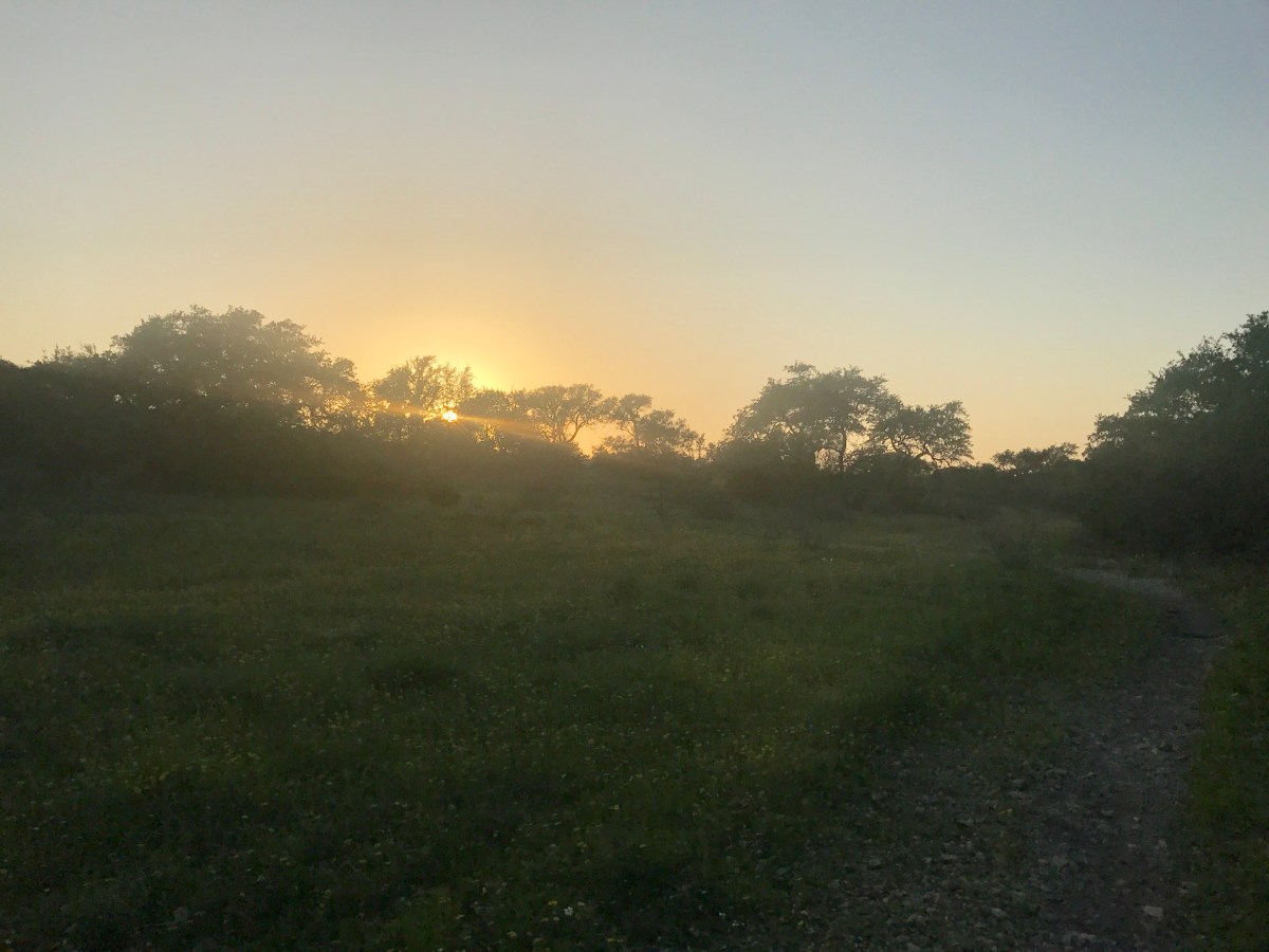
The lookout at the turnaround point is just incredible, with many different points to just sit and take in the view. My pictures don’t really do it justice but here they are anyways! the total distance I ran was 4.6 miles, with going off and turning back included. If you just went out and back I imagine it would be around 8.5 miles. I found in Australia, walking tracks are given “finishing times” more than distances, so I’d do a little covering before starting out each time- yay math!

28912128_Unknown
I took the “Via Ridge” route, and while there were some steeper sections, they were not long, and I found the grade overall completely run-able.

I did a turnoff to the Mount Banks lookout from the main trail indicated above, but that path was really overgrown and I found myself doing more hiking than running, and I returned to the main trail. On the way back I went right to a side trail instead of left   which would have led me back the way I came. That trail also became very over grown but was fun to run for a bit if you want to check it out, and maybe in another season it will be easier to get through!

I started a new workout on my watch for the way out and the way back, which is how I have two separate maps. The maps below show the main route, as well as the turn off I did on the way out up to Mount Banks (left), and then the little side route I did before I ran back to my car (right).

Map & Parking: Turn off of Bells Line of Road to the dirt road, and drive until the end.

Katoomba

The trails I was after were headed at a spot full of tourists, arriving by bus, and by car. There is a great lookout spot, and while many were hiking, most were just driving in for a view and then leaving. There was parking available for a fee, for up to 8 hours. I was lucky enough to arrive early that I found a space right away, but when I left people were waiting on the road for spaces to open up, so I’d recommend getting there early if you are driving. Even though there were a lot of people around, I found myself alone on the trails away from the lookout points quite a bit.

I took the Prince Henry Cliff Walk to Federal Pass, then came back up to where The Three Sisters, a geological formation that was super popular for photo ops, were on my way in. Going down and coming back up meant using stairs. Both routes were steep but had rails where you needed them. I grabbed a shot in front of the valley beyond the rocks. There was no one on that lookout spot except for the person holding my camera, so I was able to take in a final view without having to hustle and duck.

fullsizeoutput_e22

I really enjoyed this run. Parts of it had to be walked- like the stairs, but the rest was great for trail running. Also, the landscape was varied for such a short run (4.1 miles). There were stunning views at the beginning and end, and cool waterfalls, vegetation, and serene surroundings in the middle on Federal Pass.

There was a dining area with several options for drinks and food right there, sit down or take-away. It also had great outdoor seating. I had a coffee and a non-alcoholic cider before I left, while I decided what to do with the rest of my day. I decided to make my way back towards my digs, and assess when I was closer to home if I had another run in me and if the weather would hold off enough for me to get it in.

Pierces Pass

On the way home from Katoomba, I stopped at Pierces Pass. My host recommended it to me, and even though it was right next to Mount Banks, which I had done the day before it made for a different kind of experience. It was more of a hike, and I was going down to a river, not up to a view. I spent an hour and a half on this trail, and the going up part was actually a little easier and less tedious than going down, as it tends to be that way for me often. Total distance round trip was 3.4 miles, and took me 45 minutes each way with minimal stopping, mostly walking, and some running.

Luckily, there was a river at the bottom, and I took off my shoes and let my feet soak in the cool water. If you make your way there, there’s another path that joins the one I took down, called the “Burra Korain Blue Gum Forrest Walking Track”, and is indicated on Google Maps, and had I not been exhausted I would be able to give you more information on it, but here is the route I did take:

fullsizeoutput_e28

Link to a here for directions & parking.

Will wrap up in a second post about the rest of the trip!

Trail-run in Japan: Sapporo

I found a very legit trail (and attached network of trails) while I was in Sapporo, Japan. I had hoped to travel further into the wilderness on island of Hokkaido, the northern island of Japan, where Sapporo is located, but time and honestly, my energy stores, would not permit it. In the end, I’m very happy with the trail I did find, and plan to come back here when I can rope in a friend to do the wilder stuff with me.
I had messaged an outdoor store before leaving the USA, Sapporo Experience Base, to find out more about the area’s trails. When I was messaging I found an English speaker on the other end, but when I got to the store in person, no one spoke English. That was fine, I used a translator app and the staff were very helpful in pulling up the Suunto app/map of the area, which gave me some good ideas. The store itself had some good looking gear, especially if you are into Salomon. It was on the other side of a great park to run through, Maruyama Park. There was road and trail running, as well as a shrine and a zoo. Definitely a good option for some combo running & site-seeing, located about two miles from Sapporo Station if you want to skip transit altogether and just hoof it there.

The hardest part is finding out where to go.
Finding trails from afar in this part of the world did prove difficult for me, because none of the mapping/tracking apps I use seem popular in Japan. The REI app, “Trail Run Project” had some routes around Tokyo, but that’s about it. “All Trails” had next to nothing, furthermore, the app uselessly included common site-seeing routes as “trails”. Suunto’s app, “Moves Count” had the most information, at least around Sapporo, in the form of a heat map. I imagine that is because the brand of watch sold at Sapporo Experience Base is, you guessed it, Suunto. I may have to invest in a GPS device for future trips. Lonely Planet published a Japan Hiking Guide at one point, now out of print, and the only copies I could find were selling for US $250+ on EBay and Amazon, so I decided to make do without.

Getting to the Trail: 
Trailhead: Asahiyama Memorial Park

I took a taxi to save time, and it was about US $10 from Sapporo Station area. Many bus lines go to the area, just depends where you are coming from, hopefully you have access to the internet and can figure that part out best for you. However, there is a bus stop right next to the park, that bus line “13” hits. Try to make this stop your drop off, the others stops that are nearby are situated at the bottom of a pretty steep hill, and if you are going to be running/hiking, you’ll want to save your energy for a more scenic climb! There is also a parking lot if you have your own car.
Finding the trail:

This I did pretty much by accident, but see the picture, and you should be able to find where I headed out. After snapping some pics of the city from the main observation area (you can’t miss it), I turned up the hill and ran behind and to the right of the main building structure. From there, I kept on a well groomed path that was even paved in some places. At some point I saw a break in the forest that turned from the main path, and I took it. It was a steep, overgrown climb at first, and the climbing would continue to happen intermittently throughout the run, but overall the path was well groomed and well signed, though not in English. Meters are marked, but keep your bearings so you know which way you are headed.

I generally headed up and east. You may have more time than me and as a result would be able to add more twists and turns on. I would- it gets amazing up there. I managed to do an almost-loop, winding up at another trail head about one mile away from where I started. I really wanted to do more, but this run was at the end of my day, and my inner adult chided as I was heading further up the mountain 45 minutes before sunset- “Hey, Holly, you may get stuck out here in the dark, if we are having enough trouble navigating the terrain with light.” So my inner child sulked but down we went, and we got her Starbucks on the way home as a distraction. (If you look closely at the map of my run, you’ll see a point where I ran just a tad off course and then back- that’s me being cautious, but if I had kept going that way would have taken me to the summit of Mt Moiwa).

It was a great run, and I’ll leave here with some tips:

  • Go the direction I went if you are running (west→ east). I imagine if you are hiking it would be best as well to go from west to east. I passed three other runners & hikers, all going in the opposite direction, but the climbing going up that way would not have been any fun at all going down. (Note- the hiking/climbing was pretty tricky in some areas. I didn’t need a walking stick but I saw an older gentleman using poles).
  • This trail starts out urban, but feels pretty isolated at times. Bring water, wear shoes with good grip/teeth on them. Mind were a little worn down and I slipped at times, as it had been raining the day before.
  • There are kiosks for drinks and bathrooms at both ends of the trail.
  • Wear bugspray, they are out there and they are annoying.
  • There was a guy wearing “bear bells”. These are a thing in Japan,to alert bears that you are approaching, and I read all about them before coming here. If I was going into one of the bigger, wilder parks, I might have invested, but as it was I took my chances and it was fine.

If you don’t have a phone or GPS system, write down the kanji for signs you may come across or destinations you want ot hit. I was half a mile up from Sapporo and saw no signs in English, so I imagine in more isolated areas, whether you head further into this area or into other parks of Hokkaido, there is a chance of no English signage.


By Means of the Sole

Last Sunday I had planned on finding a new trail to run in or around Houston, or maybe revisiting one if I had too. As I sat in my living room trying to figure out where to go, I felt unmotivated to drive far, and settled for running the gravel path around Memorial Park. I had run only five other miles in the week because of some funkiness in my knee, but with the issue under control, I wanted to at least get in another hour of running before the week expired. I made two decisions. I would settle for a relatively dull run around the park, but would treat myself to a trip out of town the next weekend for something different.

Fast-forward four days, and you’ve found me writing this from a coffee shop in Austin, Texas. I found a AirBnB in West Austin, taking out a room in a house full of dudes designing an app. I was really excited at the prospect of inserting myself in a “Silicon Valley” type situation, but alas, I have no high-stakes shenanigans to report (yet). What I do have to report is that I went on a delightful trail run not long after arriving, which I’ll report on a paragraph or two down.

On my drive from Houston to Austin, I picked up listening to “The Picture of Dorian Gray”. I started it last September, on my drive from Los Angeles to Houston. It’s a dark choice, but I saw a gorgeous and grotesque artist’s interpretation at the Chicago Art Institute last June and got inspired to read (listen to) Oscar Wilde’s gothic novel. ANYWHO, a character in the novel, Lord Henry, is dependable for accurate yet somewhat depressing descriptions of human behavior and beliefs, and he tells Gray at one point that the senses are a cure for the soul, and the soul a cure for the senses. I mulled this over, as I was driving to the Texas Hill Country to cure something that I was yearning for in my soul- a taste of adventure.

When things suck, for lack of a better word, when life just doesn’t feel right, I throw myself into something that will startle, refresh, or at least be distracting for, my senses. Watch something mindless, eat like its going out of style, or seek out some sort of companionship because being alone is just unbearable. Then there are more rare moments, where nothing is as interesting as what is going on internally, and I’m pushing away all the distractions at once, so I can figure out what is happening in the space between my ears. Unfortunately I think I live more in the former mode than the latter, and I think it would be nice to flip the situation. I’ll never figure the world out, but I think I have a fighting chance of nailing down what really makes me tick someday.

Trail Running often joins those two extremes. Outside, alone on the trails I experience life first hand.  The sensory experience of the world is limited to how I take it in, no memes or sitcoms to interpret human behavior for me. This is how I get closer to answering, “Who am I”? For the record, I still am not sure.

Today’s run was great. About a mile in, as I was mulling over life events and major decisions, I crossed paths with two people on a tandem mountain bike, and they warned me about a rattlesnake they had seen. I tried to be chill about it at first, but called out as they rode off, “ON THE TRAIL?”

“YES!” they shouted back.

Yikes. I came across a freakin’ alligator on a trail not too long ago, and that was startling, but this gave me the willies. The trail had a decent amount of overgrown single track, and I didn’t feel comfortable letting myself zone out with my thoughts for the rest of the run, so I didn’t. I paid heavy attention to every step, taking in as much detail of the ground as I could with each move forward. I never saw the snake, but for my efforts in avoiding it, I caught sight of a bunny that held still as long as I needed to snap a picture, and as I turned to resume the run, three deer bounded right in front of me! If I hadn’t been looking for the snake, I wouldn’t have seen the bunny, and if I hadn’t stopped for the bunny, I might have missed the deer.

I have two more days of running to do here, and I’m really looking forward to them. Whether I see something new or think something new, its all good. Lord Henry was right, sometimes we need to get away from all the input, and other times its great to get out of ourselves.

THE RUN:

Slaughter Creek Preserve Trail


%d bloggers like this: